About Earthvisionz
Helping people make better operational decisions in real-time.
Our Mission
To integrate hundreds of sources of accurate information visualized on your map command center and delivered to key stakeholders during any critical event, minimizing risk, initiating repairs, and helping recovery professionals restore communities to normal.
Our History
Earthvisionz, Inc. evolved from Waterstone Environmental Engineering and Hydrology, a company that developed a real-time geospatial platform for the United States Air Force. One of the world’s first virtual earth platforms, it helped base managers at 13 AETC (Air Education and Technology Commands) manage environmental risk and base logistics.
The US Air Force project was revolutionary technology developed from 2002-2008 and patented in 2009. Following a series A round in 2010, Earthvisionz was formed to take the technology into the private sector.
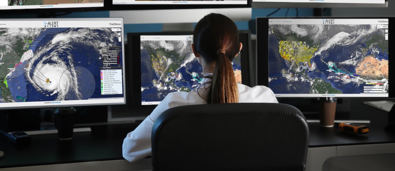
Earthvisionz has evolved into a GIS company whose core competency is integrating real-time data streams from IoT networks and visualizing that data on map command centers. There are now numerous products offered for specific types of decision support.
In 2013, Earthvisionz entered into a 5-year contract with the PGA tour to build the world’s first "live maps" fan enhancement app for tracking players on golf course imagery in real-time during PGA tournaments. The app went viral attracting over a million fans in more than 130 countries during tournament play.
In 2014, Earthvisionz began a multi-year environmental risk project with Level 3 Communications (now Centurylink) to manage environmental risk at Level 3 telecom sites. The real-time alerting system helped operation managers know what environmental impacts needed to be responded to at light speed.
These partnerships with major corporations furthered Earthvisionz' technical capabilities to manage live data on map interfaces for decision support.
Since 2016, Earthvisonz has been focused on helping companies with widely dispersed assets manage risk from natural and man-made disasters. That year the company launched Drive Tracker, a fast, affordable route optimization app to help inspectors and responders find optimal, safe routes to as many as 200 stops in a day. Benefits include saving time and money on gas and other operational expenses.
The Company has moved into commercial real estate, restoration recovery, mortgage banking, lender serves, and property and claims insurance. Also offered is a telecom risk management system and environmental engineering services on top of the core GIS platform.
In 2019, Earthvisionz graduated from the prestigious Boomtown Technology Accelerator program in Boulder CO, which helped the company advance its products and target its messaging. https://boomtownaccelerators.com/
In 2021, Earthvisionz launched Field Team Tracker, a fleet and personnel tracking system that keeps operations managers in touch with their field teams and equipment, and helps people see all threats to properties and people in the view.
Earthvisionz has won numerous awards for innovation including https://bizwest.com/login/ IQ Award in 2017. CEO Carla Johnson has been interviewed on CNN, featured in several documentaries as a water expert in the southwestern US, testified in court cases involving Hopi and Navajo Res, and interviewed in the Economist and CIO Review Magazine. Earthvisionz is a Google Maps authorized partner and was interviewed by Microsoft for an article on the emerging geospatial world. We received the "Most Innovative Company in CO" distinction at the 2008 CSIA, the 2009 "Mercury 100 - Fastest Growing Companies in Colorado", and for 10 years have been listed as one of the "Top 100 Women-Owned Businesses in Colorado". In 2015, we received the Most Innovative Software Award from the Colorado Clean Tech Association.
Earthvisionz is extremely grateful to our customers and partners who guided much of the product roadmap to the point where we now have solutions for a wide variety of business use cases, deploying maps and real-time data visualization for decision-makers worldwide.
Boomtown Demo Day
Co-founder Carla Johnson delivers pitch to a packed-house — Boomtown Demo Day 2019
Our Team
-

Carla Johnson
CEO, Co-Founder
Carla brings years of experience in 3D geospatial modeling and focuses on expanding the technology, market strategy, and business development.
-

Jeff Schott
President, Co-Founder
Jeff is a serial entrepreneur and investor with 25 years of experience growing media and technology companies. He guides market strategy and product roadmap.
-

Craig Hoff
Chief Technology Officer
With over 25 years in the IT field, Craig has been instrumental in the architecture, and development efforts of the geospatial data management system
Interested in how we can serve you?