Advancements in Hurricane Modeling and Forecasting
A Look at NOAA and NHC's Improved Tracking
When Hurricane Helene formed in the Atlantic in 2024, meteorologists at NOAA’s National Hurricane Center (NHC) watched closely. Early forecasts suggested the storm would intensify rapidly, posing a potential threat to coastal communities. But thanks to cutting-edge advancements in hurricane modeling and forecasting, NHC forecasters were able to provide the most accurate and timely predictions in history, offering communities crucial extra hours to prepare.
Pinpointing the Path with Unprecedented Accuracy
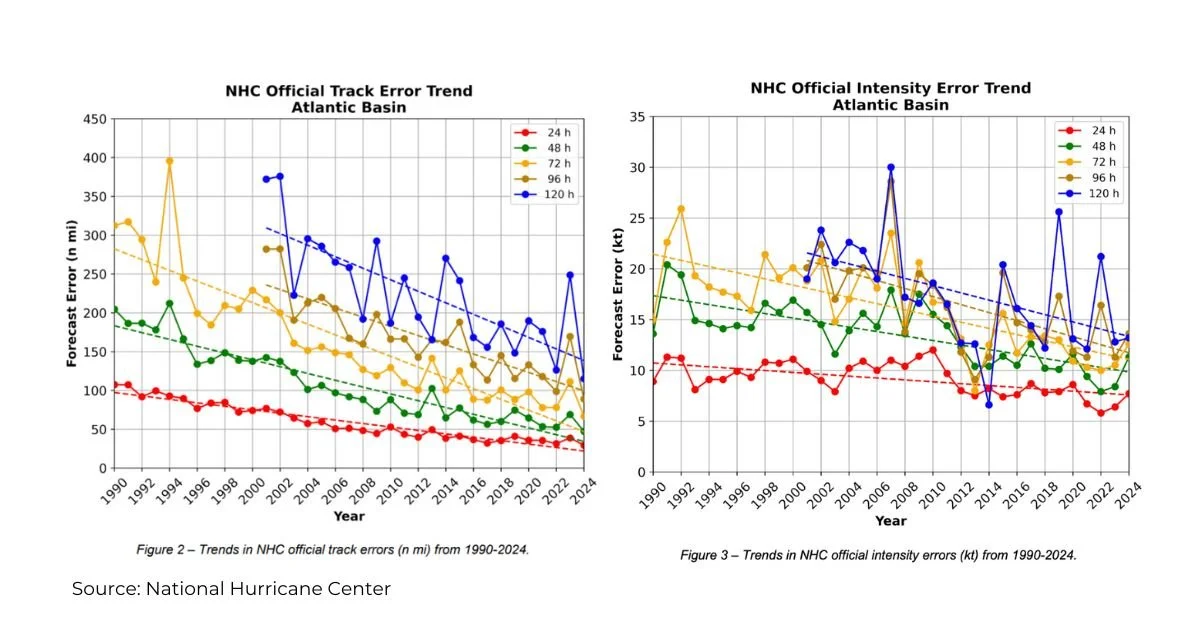
For decades, meteorologists have worked tirelessly to refine hurricane track forecasting, and in 2024, their efforts paid off. The NHC achieved record-breaking accuracy in track forecasting for the Atlantic basin, with mean track errors at all forecast intervals reaching historic lows. This wasn’t just a small improvement, it was the best track forecast performance in NHC history. Their track predictions were more consistent from cycle to cycle than those of global models, providing emergency management teams with reliable information to make life-saving decisions.
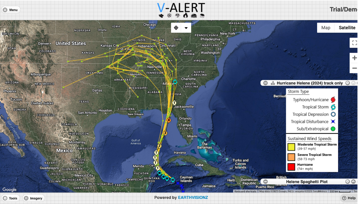
Hurricane Helene Spaghetti Models and Final Track
Tackling the Challenge of Rapid Intensification
While forecasting a hurricane’s path has become increasingly precise, predicting its intensity remains one of the most complex challenges in meteorology. Rapid Intensification (RI) (when a storm's winds increase by at least 30 knots (35 mph) within 24 hours) has historically been difficult to anticipate. In 2024, there were 34 episodes of RI. NOAA’s intensity prediction errors were a little higher than in 2023.
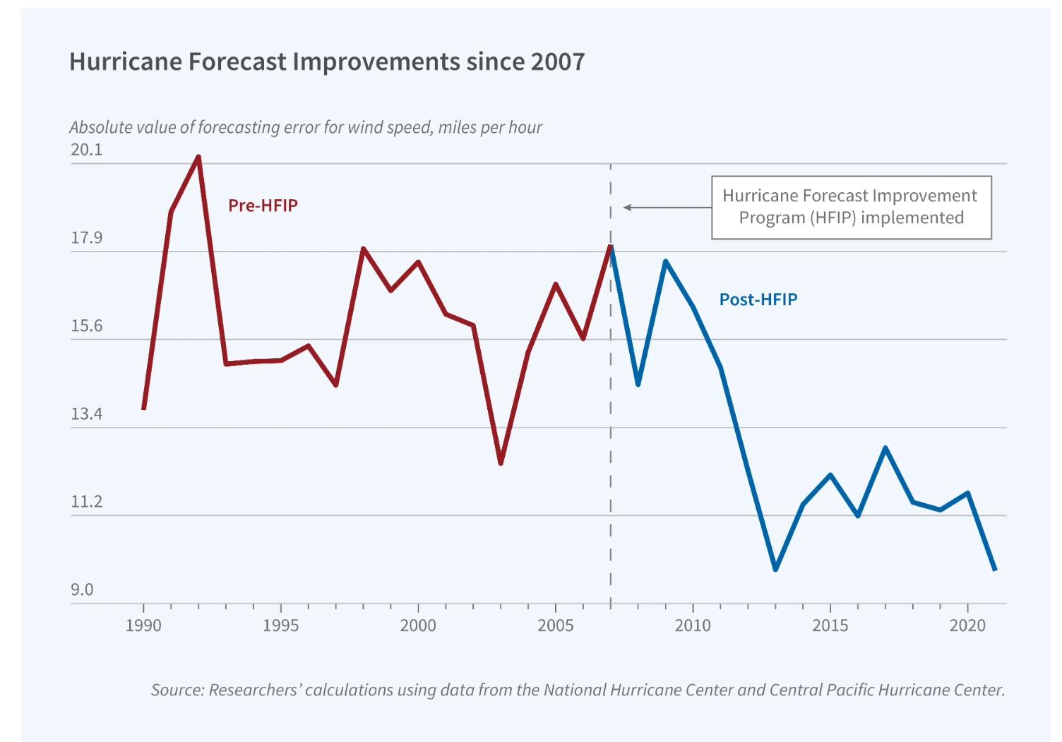
Despite what happened in 2024, NHC’s ability to detect and predict strengthening storms has improved significantly in the long term. In cases like Hurricane Milton, forecasters identified the potential for RI early, issuing warnings that helped emergency responders and residents take swift action.
Looking Ahead: The Future of Hurricane Forecasting
As NOAA and the NHC continue to push the boundaries of scientific understanding, hurricane forecast guidance will only improve. With ongoing research, new technology, and enhanced modeling capabilities, communities in hurricane-prone areas can have greater confidence in the forecasts that help them prepare and respond to these powerful storms.
The 2024 hurricane season demonstrated just how far we’ve come in predicting these natural disasters. From improved track forecasting to tackling the challenges of rapid intensification, the progress being made today is setting the stage for an even more resilient tomorrow.
For restoration construction companies, improved track forecasting allows for earlier mobilization of repair crews, ensuring materials and workers are ready to respond once the storm passes. Insurance adjusters benefit from more precise impact zones, leading to faster claims processing. Property managers can take proactive measures to secure buildings, minimize damage, and keep residents informed with real-time updates.
How Earthvisionz Can Help: Book a Demo Today
Of course, better tracking, forecasting, and more data mean you need a quick way to access and share this information with your clients and tenants. Earthvisionz can help streamline your operations by incorporating advanced modeling and weather technology into our alerts, updates, and damage assessment tools. With Earthvisionz, you can quickly assess risks, coordinate response efforts, and keep your stakeholders informed with up-to-the-minute data.
Don’t wait until the next storm is on the horizon—take control of your emergency response strategy today. Book a demo with Earthvisionz to see how our platform can help you protect your assets, improve efficiency, and ensure a swift recovery after disaster strikes.
Learn More About Reducing Errors in Hurricane Predictions
Hurricane forecasters had best year ever for tracking storms. Intensity is a different story.


