
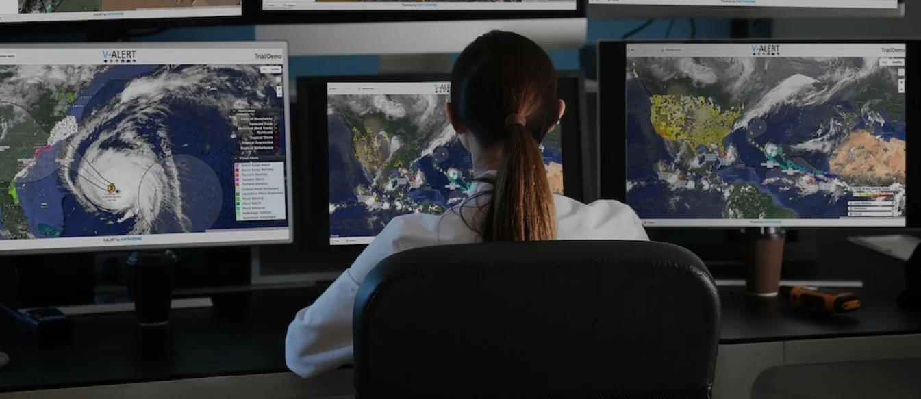


Live Map Platform for Round-The-Clock Risk Assessment and Response
All the Data, Imagery, and Decision-Support you Need in one Application
See Risks to Your Properties for Decision Support
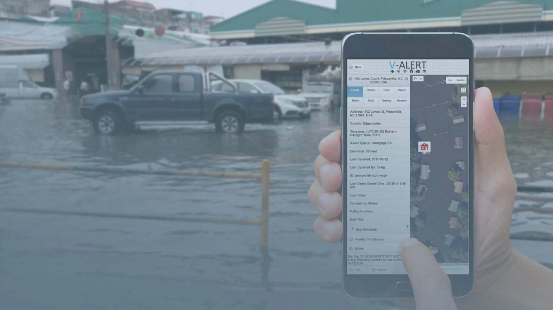
Upload and map all properties you are concerned about with property data tagged to each location.
Communicate and Get Your Field Teams on Site Fast
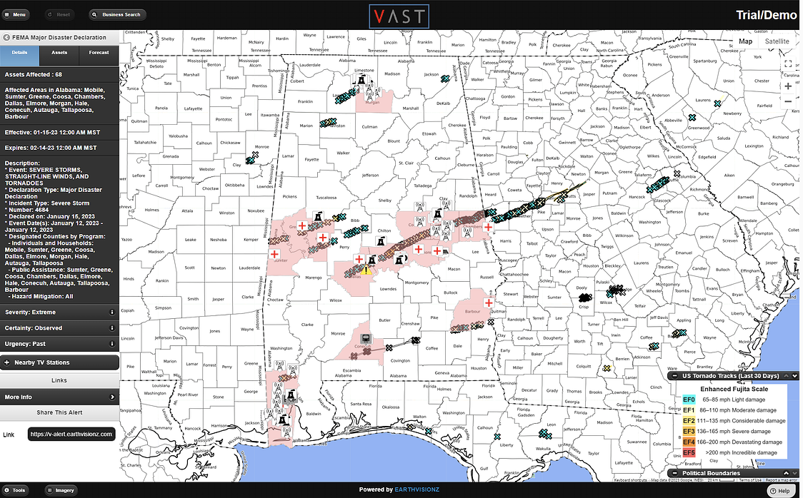
Threats to your properties visualized on the map command center using polygons and shape files.

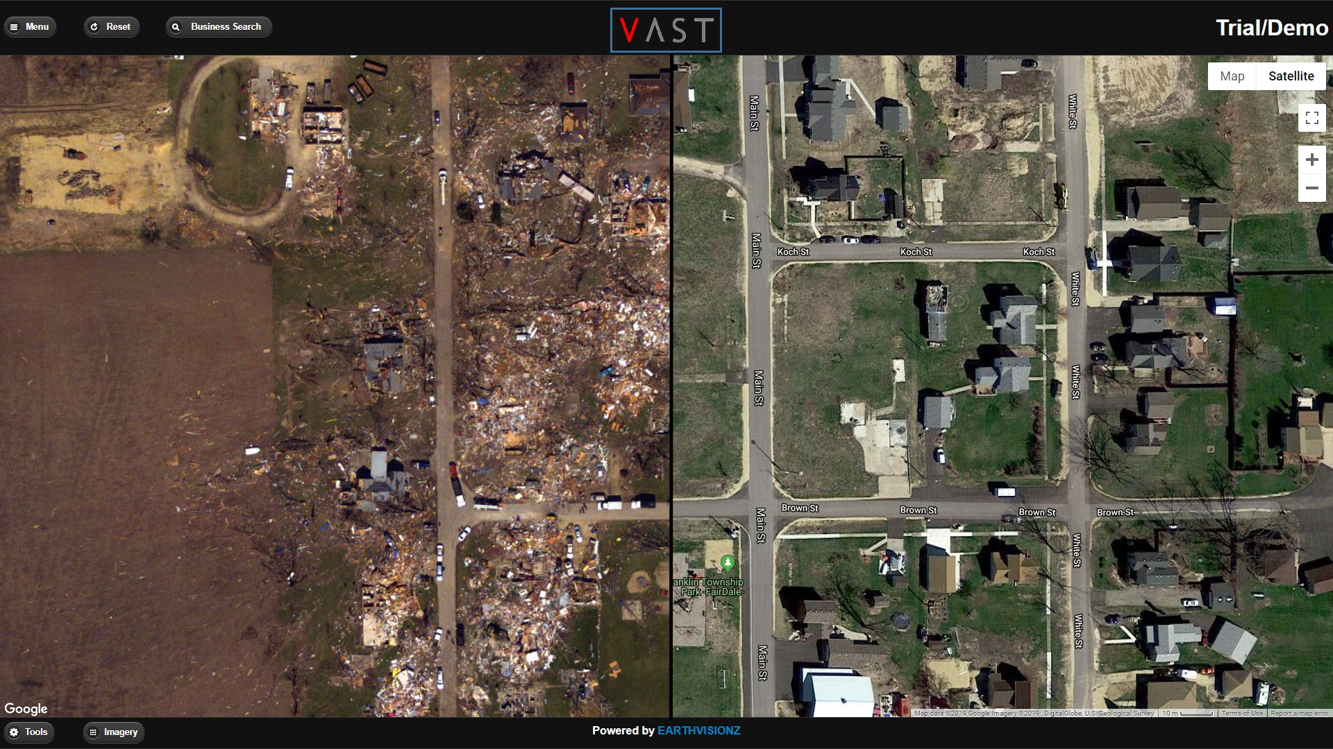
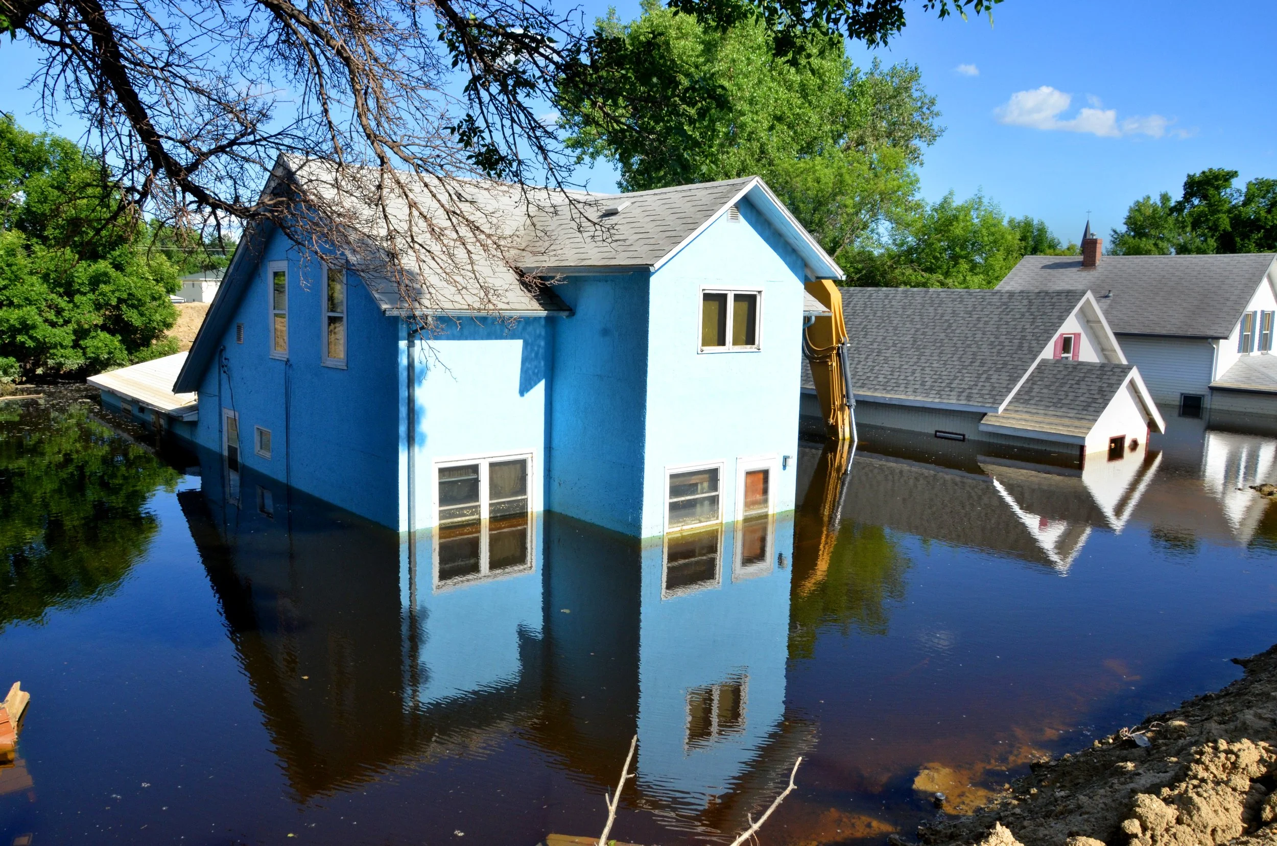
Overlay Real-Time Satellite Imagery to See Damage on Properties
Satellite imagery overlays help you assess damage once the storm has passed.
Automate Alerts to Key Stakeholders to Help Them Stay Informed
Earthvisionz aggregates data from thousands of gauges and alerts you about events damaging your properties 24/7.

Our Products
VAST Live Map Platform
Our Live Map Platform allows the integration of IOT networks to analyze large data sets about people and places you care about. Earthvisionz VAST data visualization platform enables you to see and uncover previously hidden risks and opportunities.
V-Alert Visual Alerting Services
Our Visual Alerting Services allow you and your teams to stay informed in the face of severe weather events and other disasters threatening your assets. Over 140 alert types from hyper-local gauges and sensors are delivered to relevant personnel.
Risk Management Modules
Our base map command center has a number of modules that allow you to customize for unique operational needs. Click below to learn how we integrate modules for anything from IOT networks to flood damage assessment and real estate risk analytics.
-
Earthvisionz Flood Module allows you to understand flood risk to assets of importance. When you upload assets to your map, each property is automatically ranked based on flood risk. Additionally, all FEMA flood plain boundaries are visible in relation to properties you care about.
-
Earthvisionz Fire Module includes fire scanner alerts sent to you within minutes. We cover cities across the nation to deliver you the fastest and most accurate structure fire information possible. Additionally, we have a nation-wide fire tracking map to give you information on burn damage and containment.
-
Earthvisionz Hurricane and High Wind module gives you hurricane track projections, projected wind speeds and alerting on a hyper-local basis. During a major hurricane, understand which assets have potential for damage so you can better prepare and recover after the fact.
-
Earthvisionz Winter Weather Module is perfect for everything snow and ice. Automated precipitation alerts help you increase work orders for vacant properties. Our critical weather insights help triage snow removal and prevent damage such as freezing pipes. Additionally, access our database of snow removal regulations for over 1600 cities nationwide so you can avoid fines.
-
Earthvisionz Power Outage Module gives you national coverage on catastrophic power outages. These infrastructure failures have the potential to cause significant damage and are becoming increasingly common across the grid. See large-area power outages and create action plans.
-
Earthvisionz Damage Assessment Module allows you to accurately visualize damage to assets after a disaster. We utilize satellite and crowd sourced imagery to show you exactly what damage has occurred so you can triage restoration services and estimate repair costs.
-
Earthvisionz Client Communications Module allows our users to send customized alerts to important stakeholders. Alerts can include brand icons, advertising, and PDF attachments to target prospective clients and alert current customers. Each alert contains a link to a map live map view displaying distressed assets.
-
Earthvisionz FieldTeam Tracker Module enables two way communication between operations managers and people in the field. Know at a glance where all personnel and equipment are on the map command center. Know when vendors and contractors are leaving a job site and available for a new work order.
Trusted by Industry Leaders
Enterprise climate and severe event risk management solution. Map your property inventories, authenticate users to get alerts, and see whats threatening your properties 24/7.


We also provide IoT data visualization services for the following sectors:
Government | Architecture & Engineering | Telecommunications | Smart Cities
Learn More About V-Alert & VAST
Live Alerts. Big Data. Real-Time Visualization


Simplify Business Operations
Real-time critical information, all in one place
Manage supply chain disruptions by seeing dangerous events on the map

Automated alerts for all assets you need to know about gives you peace of mind

Alerts can be customized to include your messaging and branding

Visualize data from live cams and sensors on your properties for decision support

Regulatory data from governments agencies helps you respond where fines and lawsuits are a concern

Help ensure public safety for your employees, customers and the communities they serve

Easy to use, turn-key solution

Tag critical response and recovery data to any asset to help responders show up prepared


Up & Running in 24 Hours!
Quick and easy installation means you can be operational fast!


Customer Testimonials
“First of its Kind”
I worked with Carla, Jeff and the entire Earthvisionz team for over 6 years while I was leading digital product development efforts at the PGA Tour. We engaged with them to build out the first ever “live map” experience integrating information about fixed points of interest throughout tournament venues along with the PGA Tour’s Shotlink scoring data for tracking live player location at over 40 events. It was a first of its kind effort and the Earthvisionz team hit a home run on all fronts - design, implementation, support, and just the overall working relationship with over 2M users.
D. Plant, PGA Tour Director of Product Development, 2007-2019
“Most Accurate Geo-coding Alert System”
It’s easy, fast, and accurate…really. V-Alert is the fastest and most accurate geo-coding and alerting system I have ever used. We have greatly increased our snow removal work orders and added many clients. We use it every day.
S. Preble, CTO, LPS
“Quickly Pool Resources for Response”
Earthvisionz provides real-time weather information and communication for ATI and more importantly our clients. ATI is able to quickly pool resources for response knowing exactly what client assets may be affected while our clients can engage their disaster recovery plan to mitigate loss. The partnership created by Earthvisionz is critical to the process.
T. Mette, ATI