Earthvisionz Insights: A look back at 2023 and 2024 Predictions
NOAA National Centers for Environmental Information (NCEI) U.S. Billion-Dollar Weather and Climate Disasters (2024). https://www.ncei.noaa.gov/access/billions/, DOI: 10.25921/stkw-7w73
2023 Disasters Cost Billions
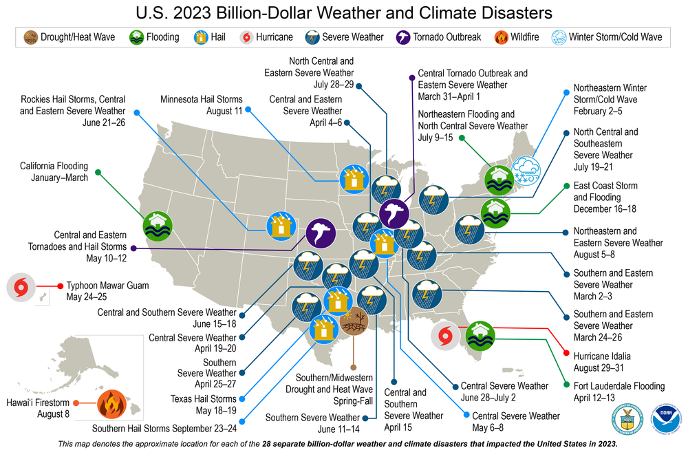
In 2023, the world witnessed a significant number of extreme weather events, with the United States alone enduring 28 billion-dollar weather and climate disasters, surpassing the previous record of 22 set in 2020. To make matters more complicated, compound extremes, where multiple billion-dollar disasters occur simultaneously or in sequence, are becoming more common, posing significant challenges for recovery efforts.
The Twenty-Eight Billion-Dollar Events Included:
1 winter storm and cold wave impacting the northeast U.S. in early February
1 firestorm that ravaged the town of Lahaina on Maui Island, Hawaii
1 drought and heat wave spanning the central and southern U.S.
4 instances of flooding occurring in California, Florida, and across the eastern and northeastern U.S.
2 outbreaks of tornadoes affecting areas in the central and eastern U.S.
2 tropical cyclones - Idalia in Florida and Typhoon Mawar in Guam
17 occurrences of severe weather and hail events observed across many parts of the country.
(From Climate.gov)
Record Breaking Heat
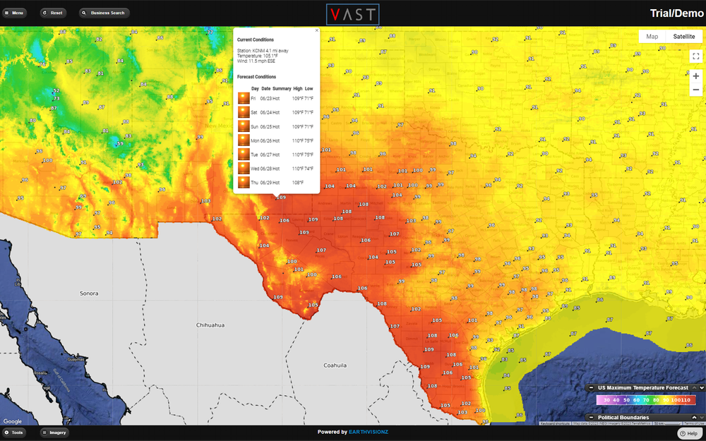
Daytime Temperatures in Texas, June 2023
In 2023, temperatures reached unprecedented levels, marked by six record-breaking months and two seasons. According to Samantha Burgess, deputy director of Copernicus Climate Change Service, this year saw the highest mean temperature for the first 11 months, surpassing the pre-industrial average by a significant margin of 1.46 degrees Celsius (2.63 degrees Fahrenheit), nearing of the 1.5 degrees Celsius limit set by the Paris Agreement.
2024 What's In Store?
As we step into 2024, the lingering impact of the unprecedented heat from 2023 persists, with Earth's oceans remaining at record-high temperatures. The heat absorbed by the oceans may take months to dissipate. The current El Niño climate pattern resembles conditions observed in 2016, previously the hottest year on record, raising the possibility of annual temperatures surpassing 1.5 degrees Celsius above pre-industrial levels for the first time. The trajectory of this trend depends on the evolution of El Niño, expected to diminish by June, though subsequent developments remain uncertain. Scientists anticipate that these conditions will lead to an increase in extreme weather events, particularly during the Northern Hemisphere winter of 2024.
The rise in ocean temperatures is expected to contribute to the formation of tropical cyclones in 2024. The temperature contrast between the warm sea surface and the cooler upper atmosphere is a crucial factor in storm development, as warmer waters provide additional energy for intensifying storms. Consequently, it is anticipated that this will result in a more active tropical cyclone/hurricane season in 2024.
Usually, during an El Niño year, hurricanes generally decrease due to wind shear tearing apart developing storms in the Atlantic. Conversely, La Niña typically leads to more tropical storms and hurricanes in the Atlantic because of reduced wind shear, or disruptive winds high in the atmosphere. Conditions are expected to switch from an El Niño to La Niña during the second half of the hurricane season, August - November. The return of La Niña with historically high water temperatures is concerning for those in the potential path of tropical cyclones. All of these signs point towards 2024 above-average number of named storms, more intense storms, and a greater risk of tropical cyclones/hurricanes making landfall in Texas and Louisiana.

Using the hurricane layer and the sea surface temperature layer on Earthvisionz' VAST platform, you can observe that a significant portion of the hurricane formation areas in the Gulf of Mexico and the Caribbean experienced temperatures ranging between 28 and 32 degrees Celsius (82 and 90 degrees Fahrenheit) in June of 2023.